WESC - A data standard for water and energy supply and consumption.
Learn more

The Water and Energy Supply and Consumption (WESC) data standard is a common representation of data for supply and consumption of water and energy. The information model allows for data to be delivered in a consistent format and is the basis for the exchange format (XML schemas) for encoding datasets for delivery through standard OGC services.
Select from the following to view each Information Model profile.
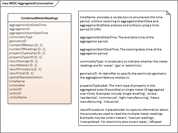
A simple tabular view of consumption, aggregated for a locality, a zone substation region, or some other spatial region e.g. a set of meter readings for properties in a metropolitan region or suburb. Indicate the location using either geometryID (a predefined region) or spatialRepresentation (a shape or polygon).
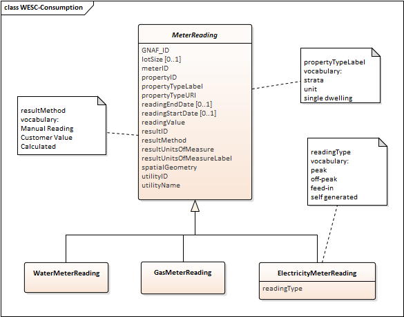
A fine-grained view of consumption based on readings for a single meter located on a property. For a single-dwelling there is a 1-to-1 mapping between the meter and the property ID, while for other property types there is a 1-to-many mapping between the meter and the property.
The general class MeterReading has the following specializations: WaterMeterReading, GasMeterReading, ElectricityMeterReading.
This view includes specific encodings for various types of readings, such as manual meter readings, indicated via the resultMethod (values selected from a controlled vocabulary).
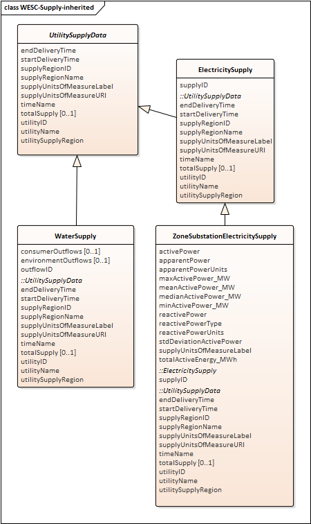
A model for supply-related data. The general class UtilitySupplyData currently has specializations for WaterSupply, and for ElectricitySupply and ZoneSubstationElectricitySupply. These capture details of the supply region (local government area, jurisdiction, statistical area, etc), of the supplying utility, and the total amount of water or electricity supplied.
The time period can be indicated using a named interval taken from a pre-defined list (timeName) as an alternative to using an explicit startDeliveryTime and endDeliveryTime. Similarly, the supply region can be indicated using a named location or as a geometry such as multi-part polygons, single polygons or points.
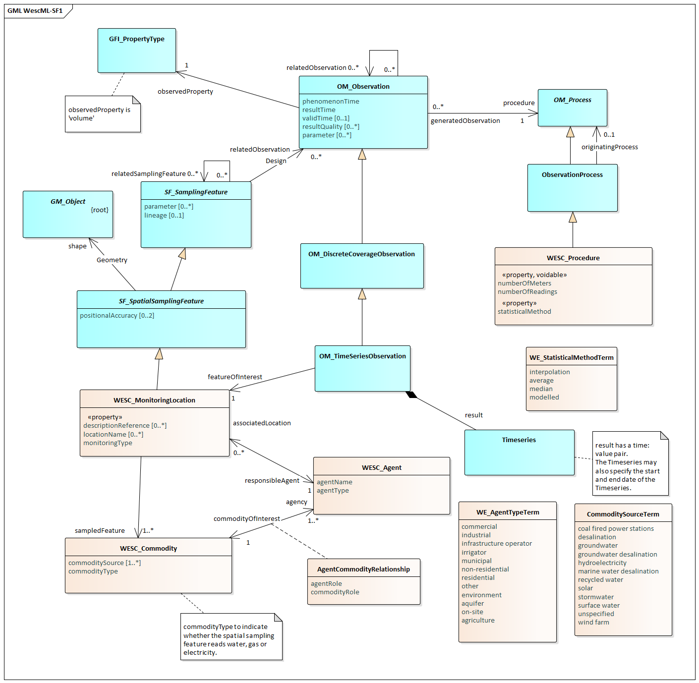
The WESCML-SF1 model is a specialization of the Observations and Measurements standard (O&M) from Open Geospatial Consortium (OGC). O&M is a model and encoding for describing a wide range of observations from multiple domains. It is based on the Geography Markup Language standard. The actual time-series data is the result of an OM_TimeSeriesObservation which samples the reporting location at different times.
WESCML-SF1 has four main classes. WESC_MonitoringLocation describes the location of a supply or consumption monitoring process, which may be a point location, or an area such as a statistical or local government region from which an aggregation of meters is reported. WESC_MonitoringLocation also captures the monitoring type (e.g. individual meter, smart meter, or locality), the location name (e.g. street address, region, jurisdiction.) and reference description.
WESC_Commodity identifies the type of commodity (e.g. water, gas, electricity etc.) being reported, and its source (e.g. desalination, stormwater, surface water, groundwater; solar, wind, grid, etc.). WESC_Agent specifies the name and type of utility, organisation, individual, population, or environment supplying or consuming the commodity. The relationship between the WESC_Agent and WESC_Commodity indicates the role each plays (consumer, supplier). WESC_Procedure specifies the procedures used to determine or aggregate the observations, including the number of meters, the number of readings, and the statistical method used to generate the results.
Three code lists standardize the values for specific properties. These are:
Controlled vocabularies for WESC
WESC includes a set of shared vocabularies to encode the content for each item, such as: result method used to measure a meter reading; and units of measure.
See here for more details: http://registry.it.csiro.au/def/wesc
Tools help data custodians deploy data infrastructure configured for WESCML include:
docker-geoserver
to create a deployment of Geoserver
using Docker containerization technologies.
wesc-sf0-node extends
docker-geoserver with configurations of the WESCML-SF0 data model, so that data custodians
can plug in their WESC datasets and deliver them via WESCML and standardised OGC web services.
Data published using the WESC standard
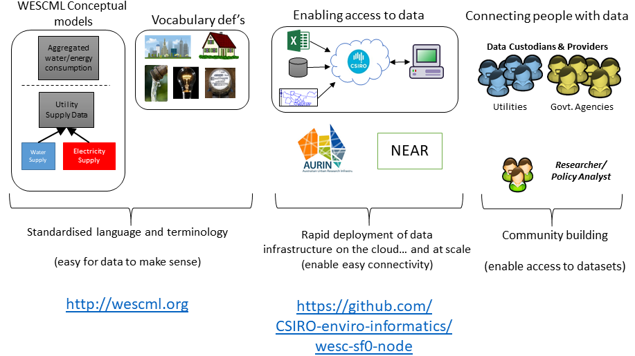
The Water and Energy Supply and Consumption (WESC) data standard has been developed by CSIRO with partners to support a common information model for supply and consumption of water and energy, and its delivery via standardised data services. The WESC information model allows for data to be delivered in a consistent format regardless of how it is represented as a data format, though there are XML data formats developed and hosted on Github.
WESCML is currently used in 2 data projects in Australia. In the AURIN project, the WESCML is being used to standardise water/energy supply/consumption data from across 16 different water and energy companies. The WESC information model is being used in the National Energy Analytics and Research (NEAR) Program for developing standardised energy data views at a national scale, e.g. zone substation electricity supply.
More information and resources are available on our GitHub site.
Issues, feedback or feature
requests can be lodged via this
link.
WESCML is maintained by the CSIRO Environmental Informatics
group with
partners from the research and industry sectors.