loci-ont
LOC-I Ontology
An ontology for Linked Data resources published within the Loc-I project.
The primary focus is on (a) datasets composed of multiple geospatial features (objects); (b) recording relationships between features, with metadata attached to reified rdf:Statements.
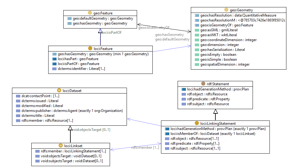 Figure 1: a diagrammatic version of this ontology’s model
This is verion 1.1 of this ontology.
Contents
The resources in this profile are:
- loci.html - nHTML odcumented version of the ontology
- see this live, online at https://linked.data.gov.au/def/loci
- loci.ttl - RDF version of the ontology
- loci.png - a diagram version of the model (also Figure 1 above)
License
The content of this API is licensed for use under the Creative Commons 4.0 License. See the license deed all details.
Citation
If you wish to cite this profile, please do so like this:
Car, N.J. & Cox, S.J.D. (2018) “LOC-I Ontology”. An OWL ontology. https://linked.data.gov.au/def/loci
Contacts
creators:
Nicholas J. Car
SURROUND Australia Pty Ltd.
formerly of CSIRO Land & Water, Environmental Informatics Group
nicholas.car@surrounduastralia.com
Simon J.D. Cox
CSIRO Land & Water, Environmental Informatics Group
simon.cox@csiro.au